| المجموعات الإجتماعية |
| البحث |
| مشاركات اليوم |


القائمة
| إضافات : P3D, X-Plane, FSX قسم خاص لعرض الاضافات المحسنه لتجربه المحاكاه , كالمطارات و السينري و البرامج المساعده |
| إضافة رد |
|
|
أدوات الموضوع |
| إضافات : P3D, X-Plane, FSX قسم خاص لعرض الاضافات المحسنه لتجربه المحاكاه , كالمطارات و السينري و البرامج المساعده |
| إضافة رد |
|
|
أدوات الموضوع |
 04-06-2008,
09:02 PM
04-06-2008,
09:02 PM
|
مشاركة [ 1 ] | |||
|
||||
|
|
بسم الله والحمد لله والصلاة والسلام على رسول الله
السلام عليكم اليكم للعبة الطيران التشبيهى اكس للصورة الحقيقية لا تقاوم واليكم الروابط 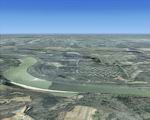 FSX Huntsville PhotoReal Scenery Package Section A. This is high resolution, 1Meter/Pixel, terrain scenery for Huntsville, Alabama. This section, A, features the Tennessee River and portions of the Redstone Arsenal. This photoscenery is for DAY USE ONLY and will work for any season, but shows only the USGS aerial photo data taken in 2002. The default FSX mesh works well with this photoscenery and no additional mesh for the area needs to be purchased. This is one section of the overall which includes sections A, B, C, D, E, F, G, H, I, J, K and L totaling 410 square miles in 946 mb. FSX Huntsville PhotoReal Scenery Package Section A. This is high resolution, 1Meter/Pixel, terrain scenery for Huntsville, Alabama. This section, A, features the Tennessee River and portions of the Redstone Arsenal. This photoscenery is for DAY USE ONLY and will work for any season, but shows only the USGS aerial photo data taken in 2002. The default FSX mesh works well with this photoscenery and no additional mesh for the area needs to be purchased. This is one section of the overall which includes sections A, B, C, D, E, F, G, H, I, J, K and L totaling 410 square miles in 946 mb. By Jim Jones. 72MB 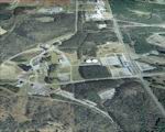 FSX Huntsville PhotoReal Scenery Package Section B. This is high resolution, 1Meter/Pixel, terrain scenery for Huntsville, Alabama. This section, A, features the Tennessee River and portions of the Redstone Arsenal. This photoscenery is for DAY USE ONLY and will work for any season, but shows only the USGS aerial photo data taken in 2002. The default FSX mesh works well with this photoscenery and no additional mesh for the area needs to be purchased. This is one section of the overall which includes sections A, B, C, D, E, F, G, H, I, J, K and L totaling 410 square miles in 946 mb. FSX Huntsville PhotoReal Scenery Package Section B. This is high resolution, 1Meter/Pixel, terrain scenery for Huntsville, Alabama. This section, A, features the Tennessee River and portions of the Redstone Arsenal. This photoscenery is for DAY USE ONLY and will work for any season, but shows only the USGS aerial photo data taken in 2002. The default FSX mesh works well with this photoscenery and no additional mesh for the area needs to be purchased. This is one section of the overall which includes sections A, B, C, D, E, F, G, H, I, J, K and L totaling 410 square miles in 946 mb. By Jim Jones. 72MB 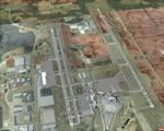 FSX Huntsville PhotoReal Scenery Package Section C. This is high resolution, 1Meter/Pixel, terrain scenery for Huntsville, Alabama. This section, A, features the Tennessee River and portions of the Redstone Arsenal. This photoscenery is for DAY USE ONLY and will work for any season, but shows only the USGS aerial photo data taken in 2002. The default FSX mesh works well with this photoscenery and no additional mesh for the area needs to be purchased. This is one section of the overall which includes sections A, B, C, D, E, F, G, H, I, J, K and L totaling 410 square miles in 946 mb. FSX Huntsville PhotoReal Scenery Package Section C. This is high resolution, 1Meter/Pixel, terrain scenery for Huntsville, Alabama. This section, A, features the Tennessee River and portions of the Redstone Arsenal. This photoscenery is for DAY USE ONLY and will work for any season, but shows only the USGS aerial photo data taken in 2002. The default FSX mesh works well with this photoscenery and no additional mesh for the area needs to be purchased. This is one section of the overall which includes sections A, B, C, D, E, F, G, H, I, J, K and L totaling 410 square miles in 946 mb. By Jim Jones. 72MB 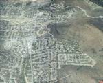 FSX Huntsville PhotoReal Scenery Package Section D. This is high resolution, 1Meter/Pixel, terrain scenery for Huntsville, Alabama. This section, A, features the Tennessee River and portions of the Redstone Arsenal. This photoscenery is for DAY USE ONLY and will work for any season, but shows only the USGS aerial photo data taken in 2002. The default FSX mesh works well with this photoscenery and no additional mesh for the area needs to be purchased. This is one section of the overall which includes sections A, B, C, D, E, F, G, H, I, J, K and L totaling 410 square miles in 946 mb. FSX Huntsville PhotoReal Scenery Package Section D. This is high resolution, 1Meter/Pixel, terrain scenery for Huntsville, Alabama. This section, A, features the Tennessee River and portions of the Redstone Arsenal. This photoscenery is for DAY USE ONLY and will work for any season, but shows only the USGS aerial photo data taken in 2002. The default FSX mesh works well with this photoscenery and no additional mesh for the area needs to be purchased. This is one section of the overall which includes sections A, B, C, D, E, F, G, H, I, J, K and L totaling 410 square miles in 946 mb. By Jim Jones. 72MB 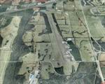 FSX Huntsville PhotoReal Scenery Package Section E. This is high resolution, 1Meter/Pixel, terrain scenery for Huntsville, Alabama. This section, A, features the Tennessee River and portions of the Redstone Arsenal. This photoscenery is for DAY USE ONLY and will work for any season, but shows only the USGS aerial photo data taken in 2002. The default FSX mesh works well with this photoscenery and no additional mesh for the area needs to be purchased. This is one section of the overall which includes sections A, B, C, D, E, F, G, H, I, J, K and L totaling 410 square miles in 946 mb. FSX Huntsville PhotoReal Scenery Package Section E. This is high resolution, 1Meter/Pixel, terrain scenery for Huntsville, Alabama. This section, A, features the Tennessee River and portions of the Redstone Arsenal. This photoscenery is for DAY USE ONLY and will work for any season, but shows only the USGS aerial photo data taken in 2002. The default FSX mesh works well with this photoscenery and no additional mesh for the area needs to be purchased. This is one section of the overall which includes sections A, B, C, D, E, F, G, H, I, J, K and L totaling 410 square miles in 946 mb. By Jim Jones. 72MB 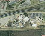 FSX Huntsville PhotoReal Scenery Package Section F. This is high resolution, 1Meter/Pixel, terrain scenery for Huntsville, Alabama. This section, A, features the Tennessee River and portions of the Redstone Arsenal. This photoscenery is for DAY USE ONLY and will work for any season, but shows only the USGS aerial photo data taken in 2002. The default FSX mesh works well with this photoscenery and no additional mesh for the area needs to be purchased. This is one section of the overall which includes sections A, B, C, D, E, F, G, H, I, J, K and L totaling 410 square miles in 946 mb. FSX Huntsville PhotoReal Scenery Package Section F. This is high resolution, 1Meter/Pixel, terrain scenery for Huntsville, Alabama. This section, A, features the Tennessee River and portions of the Redstone Arsenal. This photoscenery is for DAY USE ONLY and will work for any season, but shows only the USGS aerial photo data taken in 2002. The default FSX mesh works well with this photoscenery and no additional mesh for the area needs to be purchased. This is one section of the overall which includes sections A, B, C, D, E, F, G, H, I, J, K and L totaling 410 square miles in 946 mb. By Jim Jones. 72MB 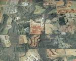 FSX Huntsville PhotoReal Scenery Package Section G. This is high resolution, 1Meter/Pixel, terrain scenery for Huntsville, Alabama. This section, A, features the Tennessee River and portions of the Redstone Arsenal. This photoscenery is for DAY USE ONLY and will work for any season, but shows only the USGS aerial photo data taken in 2002. The default FSX mesh works well with this photoscenery and no additional mesh for the area needs to be purchased. This is one section of the overall which includes sections A, B, C, D, E, F, G, H, I, J, K and L totaling 410 square miles in 946 mb. FSX Huntsville PhotoReal Scenery Package Section G. This is high resolution, 1Meter/Pixel, terrain scenery for Huntsville, Alabama. This section, A, features the Tennessee River and portions of the Redstone Arsenal. This photoscenery is for DAY USE ONLY and will work for any season, but shows only the USGS aerial photo data taken in 2002. The default FSX mesh works well with this photoscenery and no additional mesh for the area needs to be purchased. This is one section of the overall which includes sections A, B, C, D, E, F, G, H, I, J, K and L totaling 410 square miles in 946 mb. By Jim Jones. 72MB 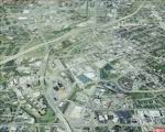 FSX Huntsville PhotoReal Scenery Package Section H. This is high resolution, 1Meter/Pixel, terrain scenery for Huntsville, Alabama. This section, A, features the Tennessee River and portions of the Redstone Arsenal. This photoscenery is for DAY USE ONLY and will work for any season, but shows only the USGS aerial photo data taken in 2002. The default FSX mesh works well with this photoscenery and no additional mesh for the area needs to be purchased. This is one section of the overall which includes sections A, B, C, D, E, F, G, H, I, J, K and L totaling 410 square miles in 946 mb. FSX Huntsville PhotoReal Scenery Package Section H. This is high resolution, 1Meter/Pixel, terrain scenery for Huntsville, Alabama. This section, A, features the Tennessee River and portions of the Redstone Arsenal. This photoscenery is for DAY USE ONLY and will work for any season, but shows only the USGS aerial photo data taken in 2002. The default FSX mesh works well with this photoscenery and no additional mesh for the area needs to be purchased. This is one section of the overall which includes sections A, B, C, D, E, F, G, H, I, J, K and L totaling 410 square miles in 946 mb. By Jim Jones. 72MB 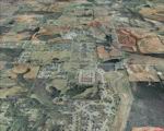 FSX Huntsville PhotoReal Scenery Package Section I. This is high resolution, 1Meter/Pixel, terrain scenery for Huntsville, Alabama. This section, A, features the Tennessee River and portions of the Redstone Arsenal. This photoscenery is for DAY USE ONLY and will work for any season, but shows only the USGS aerial photo data taken in 2002. The default FSX mesh works well with this photoscenery and no additional mesh for the area needs to be purchased. This is one section of the overall which includes sections A, B, C, D, E, F, G, H, I, J, K and L totaling 410 square miles in 946 mb. FSX Huntsville PhotoReal Scenery Package Section I. This is high resolution, 1Meter/Pixel, terrain scenery for Huntsville, Alabama. This section, A, features the Tennessee River and portions of the Redstone Arsenal. This photoscenery is for DAY USE ONLY and will work for any season, but shows only the USGS aerial photo data taken in 2002. The default FSX mesh works well with this photoscenery and no additional mesh for the area needs to be purchased. This is one section of the overall which includes sections A, B, C, D, E, F, G, H, I, J, K and L totaling 410 square miles in 946 mb. By Jim Jones. 72MB 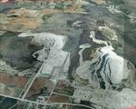 FSX Huntsville PhotoReal Scenery Package Section J. This is high resolution, 1Meter/Pixel, terrain scenery for Huntsville, Alabama. This section, A, features the Tennessee River and portions of the Redstone Arsenal. This photoscenery is for DAY USE ONLY and will work for any season, but shows only the USGS aerial photo data taken in 2002. The default FSX mesh works well with this photoscenery and no additional mesh for the area needs to be purchased. This is one section of the overall which includes sections A, B, C, D, E, F, G, H, I, J, K and L totaling 410 square miles in 946 mb. FSX Huntsville PhotoReal Scenery Package Section J. This is high resolution, 1Meter/Pixel, terrain scenery for Huntsville, Alabama. This section, A, features the Tennessee River and portions of the Redstone Arsenal. This photoscenery is for DAY USE ONLY and will work for any season, but shows only the USGS aerial photo data taken in 2002. The default FSX mesh works well with this photoscenery and no additional mesh for the area needs to be purchased. This is one section of the overall which includes sections A, B, C, D, E, F, G, H, I, J, K and L totaling 410 square miles in 946 mb. By Jim Jones. 72MB 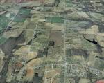 FSX Huntsville PhotoReal Scenery Package Section K. This is high resolution, 1Meter/Pixel, terrain scenery for Huntsville, Alabama. This section, A, features the Tennessee River and portions of the Redstone Arsenal. This photoscenery is for DAY USE ONLY and will work for any season, but shows only the USGS aerial photo data taken in 2002. The default FSX mesh works well with this photoscenery and no additional mesh for the area needs to be purchased. This is one section of the overall which includes sections A, B, C, D, E, F, G, H, I, J, K and L totaling 410 square miles in 946 mb. FSX Huntsville PhotoReal Scenery Package Section K. This is high resolution, 1Meter/Pixel, terrain scenery for Huntsville, Alabama. This section, A, features the Tennessee River and portions of the Redstone Arsenal. This photoscenery is for DAY USE ONLY and will work for any season, but shows only the USGS aerial photo data taken in 2002. The default FSX mesh works well with this photoscenery and no additional mesh for the area needs to be purchased. This is one section of the overall which includes sections A, B, C, D, E, F, G, H, I, J, K and L totaling 410 square miles in 946 mb. By Jim Jones. 72MB 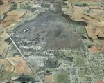 FSX Huntsville PhotoReal Scenery Package Section L. This is high resolution, 1Meter/Pixel, terrain scenery for Huntsville, Alabama. This section, A, features the Tennessee River and portions of the Redstone Arsenal. This photoscenery is for DAY USE ONLY and will work for any season, but shows only the USGS aerial photo data taken in 2002. The default FSX mesh works well with this photoscenery and no additional mesh for the area needs to be purchased. This is one section of the overall which includes sections A, B, C, D, E, F, G, H, I, J, K and L totaling 410 square miles in 946 mb. FSX Huntsville PhotoReal Scenery Package Section L. This is high resolution, 1Meter/Pixel, terrain scenery for Huntsville, Alabama. This section, A, features the Tennessee River and portions of the Redstone Arsenal. This photoscenery is for DAY USE ONLY and will work for any season, but shows only the USGS aerial photo data taken in 2002. The default FSX mesh works well with this photoscenery and no additional mesh for the area needs to be purchased. This is one section of the overall which includes sections A, B, C, D, E, F, G, H, I, J, K and L totaling 410 square miles in 946 mb. By Jim Jones. 72MB مع تحياتى |
|||

|

|


